


GPS area measure - land survey
GPS area measure - land survey의 설명
Want to know the true size of your land?
Measure the perimeter of a field?
Determine the exact position of that border stone?
Collect GPX-data and visualize at home?
How to use:
Simply press the green button "GPS WALK" and start walking.
Now walk along the border of the area.
If there is any obstruction just press "PAUSE" and move on to the next accessible point.
Continue with "GPS WALK" or "GPS POINT HERE".
Once you are done click "CALCULATE" and the app will determine the area and perimeter.
The last position will automatically connect with the first position so you do not need to worry about closing the area exactly.
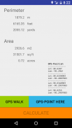
For convenience, area and perimeter are presented in imperial and metric units,
"m2", "acre", "squarefeet" for areas and "m", "feet" and "yards" for perimeters.
Now you can send the GPS-data via email to your (or other peoples) mail-account.
Cut the GPX-part and paste it into one of the many GPS-visualizers available on the Internet.
How it works:
The app strictly follows the WGS84-model to transfer Latitude- and Longitude-data to metric distances between waypoints.
WGS84 is currently the reference system being used by the Global Positioning System.
It originally used the GRS 80 reference ellipsoid, but has undergone some minor refinements in later editions since
its initial publication. WGS 84 uses the EGM96 (Earth Gravitational Model 1996) geoid, revised in 2004.
This geoid defines the nominal sea level surface by means of a spherical harmonics series of
degree 360 (which provides about 100 km latitudinal resolution near the Equator).
Permissions needed:
android.permission.ACCESS_FINE_LOCATION
android.permission.ACCESS_COARSE_LOCATION
android.permission.ACCESS_LOCATION_EXTRA_COMMANDS
android.permission.LOCATION_HARDWARE
this app will:
- measure acreage
- convert acres to square feet (internal)
- assists in land survey
- measure the total distance of your waypoints
- calculate perimeter
- area measurement
- fields area measure
- gps walk
GPS area measure - land survey - 버전 1.14
(26-02-2020)GPS area measure - land survey - APK 정보
APK 버전: 1.14패키지: com.sekora.deviceloc1GPS area measure - land survey의 최신 버전
다른 버전들


동일 카테고리의 앱

좋아할 만한 것...


